Kaweah Mile 72 to Hamilton Lake to Middle Fork Trailhead
(19 miles, +5,000/-8,000 feet).
Wow.
Just wow.
Today was one of the most epic days of hiking I have ever experienced.
I’m not sure I want to repeat some parts of it, but I feel really psyched to have achieved a crazy-hard goal and to have seen the extreme beauty of the spring Sierra.
After an hour of bushwhacking last night I set up camp and collapsed.
I had no idea what was coming!
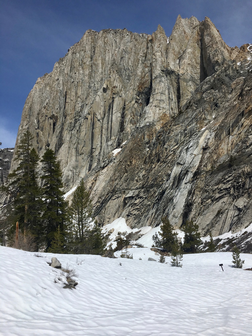
The next morning the eastern sky brightened over my objective: the High Sierra Trail where it crosses the Kaweah just above some beautiful falls. I still was not sure how I was going to get up there, so I was eager to get some open views.

Ultimately it took me 3.5 hours to travel about 1.5 miles. That’s about 5 times slower than my normal trail pace!
The willows got even thicker and increasingly I had no choice but to wade through them. Add to that the steepening walls, and you get a recipe for slow.

I was grateful for the occasional boulder or snow field where I made much better time.

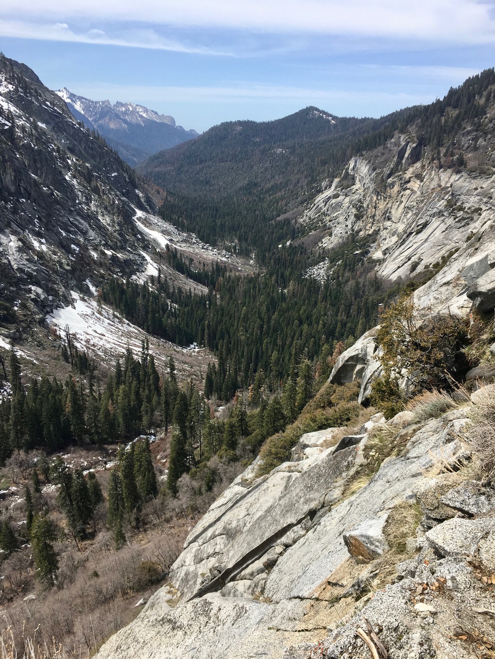
I stayed pretty high on the southern wall of the canyon. Sometimes I would look down at the floor near the river and it seemed like it might be open down there. But the brownish-red tint usually meant willows, and if anything they seemed to be more difficult on flatter terrain.


As I neared the falls it became increasingly apparent that climbing up on the south side of the Kaweah was not in my skillset. I could not see anything that looked easier than class 4.
I would have to cross the Kaweah.
And without a bridge!
I decided to make for the top of a lower set of falls where I hoped to find a calm flat part.


I started bouldering up next to the river, checking every 100 feet or so to see if I could find a place to cross.
Then finally I found a place, not far below the upper falls. A log got me halfway across and the next ten feet were clear, not too fast, and only thigh deep.


When I got to the other side, I found someone else’s lost water bottle. In the name of making amends with the universe for my own unintended wilderness plastic deposit, I picked it up and packed it out. (Now if only I could find someone’s peanut butter jar!)


A series of ledges and slabs took me most of the way up to the High Sierra Trail. At one point I did a class 3 move to avoid another 40 feet of willows. And then before I knew it I was done.


Before sitting down to take a break I wanted to make sure I could cross the Kaweah yet again above the upper falls. But this part was easy. Two logs even helped me to keep from getting my feet wet again.

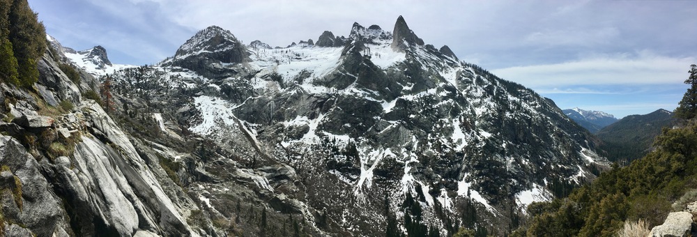
I took a much needed break a few feet past the crossing, munching on Triscuits and beholding Valhalla.

After my break I continued on the trail up towards Hamilton Lake. By about 7900 feet the trail was completely covered in snow.

One thing I really love about walking in the snow is that it gives you the impression that no one has ever been here before. A smooth white canvas waiting for a solitary line of footprints.


The hike from the first to the second lake traverses on a very steep slope. I did not take any pictures because I was concentrating on taking careful steps. In hindsight I probably should have put my crampons on (I definitely put them on for the descent!), but there were only two spots icy enough to make it seem necessary and I managed those in my trail runners.
When I arrived at Hamilton Lake proper, I began to cry.


Once I regained my composure I realized I should probably get going. The sun was strong and I had already noticed an increase in postholing on the way up. As I made my way back down I took in the fantastic Valhalla towers that loomed above.


With crampons on my feet I felt more confident on the way down and I was able to snap photos.


By the time I got back to the falls my feet were soaked, so I skipped the log and just waded across.

My next objective was Bearpaw Meadow. I was a little worried about lingering snow on the trail, but it was fine. The toughest spots were a steep couloir that had plenty of runout if I slipped down about 20 feet or so and some snow on trail down to the Lone Pine bridge. But the snow was soft and it was easy to plunge step in just my trail runners.


By 1:30pm I was in Bearpaw Meadow, a High Sierra Camp that was closed for the season.


At this point I had to decide what I wanted to do. I had about 6 hours until sundown and it was about 14 miles back to the car. That’s faster than my normal pace, but a lot of it is downhill so I decided to go for it.
Snow stayed with me on and off down to Little Bearpaw Meadow.


It got very hot and very muggy as I descended. Add to that the absence of any breeze whatsoever and you get swarms of thirsty gnats who enjoy spending time with you (even if you don’t enjoy spending time with them!). So for the last five miles I donned my headnet, put some tunes on my headphones, and picked up the pace.


By 7pm I was back at the car and by 12:30am back at home in San Diego.
It was a really quick trip but I really liked the challenge. I don’t think I would plan to bushwhack through willows again, but I’m really happy I tried it (though my battered shins aren’t!). At least now I know what it’s like if I ever find myself in a situation where it’s necessary I’ll be able to do it. And it was a real confidence builder to be able to routefind my way up to the HST, do some class 3 moves, and use my snow equipment to traverse steep slopes, all while traveling solo and trying to minimize risk.
I can’t wait for my next adventure!

I was gonna ask if you did any guided trips. But after this last post I think I’ll live vicariously through your hikes. Gorgeous pics. Great write up. Been following your adventures for a while.
LikeLiked by 1 person
That…looks…incredible!
LikeLiked by 1 person
It was! Can’t wait for our July trip!
LikeLike
“The sun was strong and I had already noticed an increase in postholing on the way up.” What is “postholing”?
LikeLiked by 1 person
Postholing happens in snow that is melting. Your foot punches through the upper surface to a cavity below that can be 1 inch to ?? feet deep depending on the depth of the snow pack and your location. It’s especially likely near rocks and fallen logs where the melting happens faster and creates more cavities below. It can be dangerous if you posthole onto a sharp branch or just fall hard enough to hurt your leg. But it can also be helpful if the postholing is only a few inches because it allows you to easily create steps in the snow when you are traversing a steep slope.
LikeLike
I see. Thanks!
LikeLiked by 1 person
FABULOUS POST! One of my favorites so far. Wonderful photos and stories!
LikeLiked by 1 person